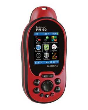
DeLorme Earthmate PN-60 Portable GPS Navigator
September 19, 2018 - Comment

The rugged, reliable Earthmate PN-60 delivers next-generation GPS capabilities, plus DeLorme’s market-leading map and aerial imagery displays. DeLorme Topo North America desktop software and GPS maps are included, with comprehensive detail for all your favorite outdoor activities in the U.S and Canada. Aerial imagery, nautical charts, and supplemental USGS and Canada topo maps are also available.
Next-generation GPS capabilities, plus DeLorme’s market-leading map and aerial imagery displays. 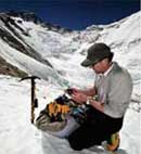
Tested in the world’s most extreme conditions. 
Find your position on up-to-date DeLorme Topo USA 9.0 maps.
View cutaway elevation profiles with your position pinpointed.
Key Features
Intuitive icon-based user interface for easy on-device navigation Elevation profile cutaway views that pinpoint the user’s position GPX file exchange (waypoints, routes, tracks, and geocaches) to SD card for ease and flexibility in archiving collected GPS data Latest DeLorme power management system with ambient light sensor for optimal battery life 3.5 GB of user-available Flash memory
Maps
Whatever your preferred activity, you’ll never have to settle for just one map. Find your position on up-to-date DeLorme Topo USA 9.0 maps (included). Navigate worry-free with complete U.S. topographic detail, extensive trail coverage, U.S. and Canada streets, roads, and places of interest including campgrounds, boat launch sites, unique natural features, prime hunting and fishing spots.
The PN-60 comes with up-to-date DeLorme Topo USA 9.0 map detail included, both on PN-Series Map DVDs (Mac-compatible) for transfer to the GPS, and in a PC desktop software program.
Outdoor Activities
The PN-60 supports all popular outdoor activities. Features include a highly-accurate 3-axis electronic compass that works when held in any position, moving on foot or standing still. For traveling in elevation, there is an elevation profile tool that pinpoints your location and a sensitive barometric altimeter for precise elevation readings and the ability to gauge potential weather changes. These elevation features are particularly useful for hikers, climbers, and hunters. The ability to display NOAA nautical charts make the PN-60 a valuable navigator for sea kayaking and coastal sailing.
The PN-60 fully supports paperless geocaching, and offers almanac pages with information on tides, hunting and fishing favorability, and sunrise/sunset and moon phases.
Geocaching
DeLorme has devoted significant resources toward offering a rewarding geocaching experience. In addition to the unique value of available aerial imagery, the PN-60 delivers a wide range of paperless geocaching capabilities.
Individual caches can be downloaded, with all information included, from Geocaching.com. The PN-60 and Topo USA also support imports of high volume Pocket Queries from Geocaching.com, and they allow virtually unlimited cache description character counts, so you’ll have all the information you need on the device, including other cachers’ log notes.
The optional DeLorme Cache Register download delivers enhanced paperless geocaching functions. Sync your Pocket Query search results directly to the PN-60, and sync your user logs and other cache details to Geocaching.com.
DeLorme is the innovation leader in high-quality maps and GPS units for everyone from recreational customers to businesses to government agencies. Proven in the most extreme conditions, from the bitter cold of the North Pole and Mt Everest to the heat and sand of Iraq and Afghanistan, DeLorme products are well known for rock-solid design, accuracy, and reliability. DeLorme is a disabled veteran-owned small business (SDVOSB) and takes great pride in engineering outstanding maps, software, and GPS units right here in the United States.
Earthmate PN-60 GPS, Topo North America 9.0, 5 Regional Discs of PN-Series Maps, User Manual, Quick Start Guide, 2 Energizer e2 Lithium AA Batteries, USB Cable, Certificate for $40 Worth of Data Downloads, Neck Lanyard
Comments are disabled for this post.
All4Hiking.com is a participant in the Amazon Services LLC Associates Program, an affiliate advertising program designed to provide a means for sites to earn advertising fees by advertising and linking to Amazon.com, Endless.com, MYHABIT.com, SmallParts.com, or AmazonWireless.com. Amazon, the Amazon logo, AmazonSupply, and the AmazonSupply logo are trademarks of Amazon.com, Inc. or its affiliates.
Not what I had hoped… 2014-11-26Another bad product.I should have looked on the Delorme Forums site before purchasing this unit.It seems that these GPS units will not connect at all with Windows 8 computers and apparently have troubles with later versions of Windows 7.The unit I had also had a bad USB cord and would not even appear as a set of drives when connected to older machines (I tried three others…).The mapping software that came with the unit looked to…
Not user friendly. Poor support. Have had this unit for over 30 days…and still can’t figure out how to do anything I want to on it. Called Customer Service and said “How do I do……” Their reply was “We don’t do ‘how to'” So I’m stuck with it. Guide is not user friendly. I would like a section that says “This is what I want to do…how do I do it?” and Step-by-Step instructions. So, I’m stuck with a device I don’t understand and wish I had returned it in the 30 day period.
Would Not Recommend I’ve had the PN-60 for about 3 years & don’t like it. I lazily put up with its shortcomings through the warranty period but when I really needed it, it was too late. Bring a compass & a map. I bought it to use on long bicycle exploration trips, 12 hours or more. It was useful mostly to zoom out to make sure I wasn’t headed on a dead end route & somewhat useful as a trip statistic computer. It would freeze up after it went into sleep mode if I stopped riding to eat a power bar & such. Would…