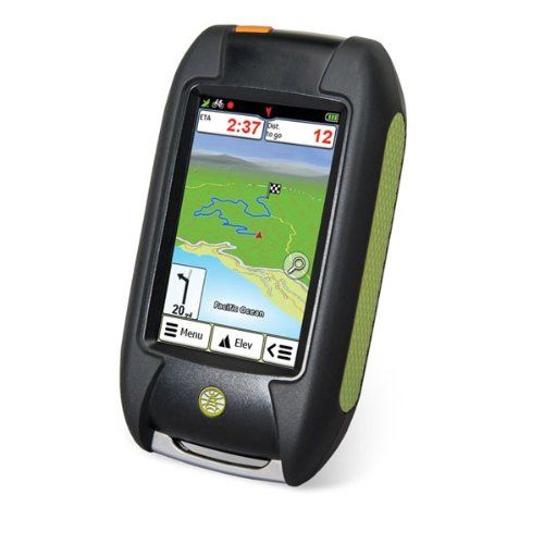
The latest GPS device from the most trusted name on the map is ready for hiking, biking, geocaching, and more. The Foris 850 comes loaded with trail and road maps and includes turn-by-turn directions with voice guidance. It’s also equipped with advanced outdoor routing features to calculate a looped route, route along a saved track, and compare alternate routes.
Product Features
- More than 5 million miles of trails and roads
- Detailed U.S. street and contour maps, including water features
- Trail navigation with spoken and visual turn-by-turn
- Paperless geocaching with storage for 7,000 waypoints and 1,000 tracks
- Rugged and waterproof; 3″ touchscreen; compass and altimeter
Comments
Comments are disabled for this post.


Hangs during navigation and does not recover properly While navigating the first route with the unit, it hung after the halfway point. The power switch was non-responsive, I had to remove and replace a battery. When I the navigated the route again, the unit asked if I wanted to navigate from my current position instead of the beginning, and selected OK, but the unit routed me backwards (u-turn) to the halfway point, instead of the next point in my route, and continued to do this when even when I got to the next point, I also tried to stop and…
GP YES Pretty good for under 100$. Picks up satellites fast, maps are basic but accurate. Fairly easy to use, first time was a learning curve, than found more thorough instructions online, second use was a breeze. Battery life is decent with alkaline, haven’t used any rechargeable. Works well for geocaching by entering coordinates. It’s not recognized by geocaching.com. Definitely would buy again, there’s probably better out there, but definitely not under 100$. Reason it’s so cheap is because it was…
an utter failure I was planning to hike rim to rim through the Grand Canyon and wanted a GPS to help keep track of altitude and distanced as well as location. This device failed miserably. First it is not easy to use. Even after reading the start guide and instruction book, trying to pre plan a hike while still at home was trying to say the least. I couldn’t do it. Once there, still impossible to mark our camping sites on the plan, in spite of an hour of effort. So I settled for just recording the hike…